
Higher Eastwood is a small cluster of houses on the North hillside and was the original settlement at Eastwood. In 1851 it was known as Eastwood (reflecting the absence of dwellings in the bottom of the valley), it later became known as Upper Eastwood (presumably as Eastwood in the bottom of the valley grew). We are unsure when it became known as Higher Eastwood.
The hillside above Higher Eastwood had many farms, some have disappeared, many have become private dwellings. The last section of this page (Other Settlements) tries to plot the evolution of settlement on this hillside.
We are deeply indebted to Jack Shackleton who provided much of the information on this page. Jack died in 2008.
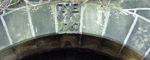
EASTWOOD HALL
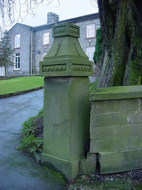
Note the Eastwood family arrow symbol on the gate posts (which can also be seen on the arch below).
Above Eastwood Hall are three buildings:
- The coach house for Eastwood Hall is now a dwelling called Glen View.
- Old Hall Barn, now a dwelling, looks to have been built in the Nineteenth century. However it seems to have been built on the site of an Seventeenth century twining mill. This was probably referred to as Lower Mill which was used for cotton spinning. In the grounds is a vertical brick shaft used for washing fleeces.
- Meadowcroft is a Twentieth century dwelling built on the site of of a previous dwelling (built around 1805) called Eastwood House farm.
OLD HALL FARM
This Seventeenth century dwelling is on the right. It used to be known as Eastwood Old Hall, perhaps until Eastwood Hall above was built. It was built in 1767 by Thomas Manley Eastwood and remained in the Eastwood family until 1929.

To the West of Old Hall Farm is a building which used to be a toll house. The tolls were mainly for horse and carts carrying stone from the many quarries on the hillside. The carts were so laden that an assistant drew water from the many wells around to pour over the metal wheel rims and brakes to cool them down.
Directly behind the house is a separate yeoman clothier’s shop of c.1710. Under its roof, is an attic partly used for cooping birds. Flight ledges and entrance holes are sited on the west gable, though the openings themselves are now blocked.
EASTWOOD SHED
This mill was used for cotton weaving. It was built in two sections around 1840. It had a take in shop for weaving pieces, probably Kersey (low grade cotton) - 30 feet long and 4 foot wide. It had room for 144 looms, many of which came from Cow Bridge Mill in Jumble Hole. It was powered by an overshot wheel fed by Staups dam on the hillside with a small holding dam just above the mill. This was later replaced by a horizontal Lancashire steam boiler which was dragged up the hillside from the bottom by 12 chained horses.
The mill was made bankrupt on several occasions and finally closed in 1929. The iron was used as a part of the war effort and the chimney was taken down and used to build dry stone walls in the locality. In the 1950s, the mill was used for hens and chickens and later used milking cows. It is now a workshop.
Click here for more information on Eastwood Shed.
TERRACE
This terrace of dwellings is known as 4, 5, 6, 7 & 8 Higher Eastwood. It was built by John Eastwoode in 1630 in the reign of Charles the First. Charles the First wanted to make John Eastwoode a "sir", but he refused saying he couldn't afford the cost. He was fined £10 for contempt.
In the 1880s the cottages were part of a lease of Eastwood Shed.
The dwelling at the West of the terrace was built much later.

The dwelling above the terrace (number 9 Eastwood) was built around the same time as the terrace.
UPPER MILL
Number 10 and 11 (also known as Rose Cottage) was also built in the mid Seventeenth century. Above the building is the site of a small dam with a culvert going into Rose Cottage. This use of water power probably indicates that it was the site of Upper Mill. In the early Nineteenth century Upper Mill was recorded as being used for spinning cotton and worsted. In 1805 it had four mules with 844 spindles.
From the Stansfield rate book it appears that Upper Mill was leased out (with Eastwood Shed) from about 1854. However, from 1868 it is standing empty for ten years. In 1880 when Eastwood Shed is revalued there is no mention of Upper Mill, probably indicating that it was no longer being used as a mill. The building is now a residential dwelling.
OTHER SETTLEMENTS ON THE HILLSIDE
The hillside was very populated from the 17th century with many dwellings being used for farming and weaving. The Eastwood and Mitchell families owned many of the farms and many are still in existence.
Great house and Great House Clough
These were in existence in 1670 as Oliver Heywood was holding chapel meetings at Great House that year (more details on Eastwood Chapel page). In 1788 Great House was owned and occupied by Luke crossley. Great House Clough was occupied by a Jonathan Harrison (a cattle doctor) who died there in 1870 aged 72.
Pex tenements
We have no information on this at present.
Field Top
This was also known as Syke Field and Ivy Cottages. These two dwellings on Eastwood Lane were in existence in the 1850s. We have no further information on them at present.
Upper East Lee
Upper East Lee was used for weaving as well as farming. It was farmed by the Sutcliffes at some time. It was connected to Old Hall farm by a footpath.
Lower East Lee
Lower East Lee Farm is dated from 1631.
Mount Pleasant
Mount Pleasant was a three story dwelling, It was in existence in the 1850s. It is believed that it used to be a work house and also a toll house in earlier days.

The photo shows the toll gates at the top of the road (in the bottom left hand corner).
The house was later divided into two dwellings and owned by the Nye family from the 1940s, but in the 1960s the top story was removed and it was made into one house and greatly modernised.

The greenhouse has gone, the trees have grown and the garden is extended by land rented from a local farmer.
It is thought that the poem below was written by Allan Barker in the early 20th century. The poem may indicate that Mount Pleasant was formerly (or locally) called New Biggin.
I live at Mount Pleasant
A place in Eastwood,
If I call it New Biggin
It would be better understood.
Mount Pleasant is three stories high.
With a grand lookout.
On a nice summer's day.
There's fields all around it.
Covered in green,
I don't think there's anything.
Unfit to be seen.
There's a garden at the end.
That I garden myself.
And sometimes look around it.
To see if all's well.
One day in my walks.
I was sorry to find.
That some naughty boy.
Had been very unkind.
He'd pulled off the berries.
And thrown them on the floor.
I thought if I'd caught him.
He'd do it no more.
But turn to winter.
Where Christmas comes on.
How starved we all are.
Especially our john.
For the house is a cold one.
And cold winds come in,
If you don't mind it's raining.
You get wet to the skin.
But we're hoping things will be.
Mended before next spring.
Or Cock a Bob will.
Make a rare din.

The three photos of Mount Pleasant have been sent to us by Audrey Watts who lived at Mount Pleasant in the 1950s and now lives in Australia.
Chapel House
This dwelling was in existence in the 1850s. It was built as a Chapel originally names Benthead (see Eastwood Chapel page for more information). Reputedly John Wesley once preached there.

The photo is taken from the top floor of Mt Pleasant. In the background behind the houses you can see "Devils Rock" near the trees.
Cockhill cottage
This dwelling was in existence in the 1850s. We have no further information on this at present.
Birks
This dwelling was in existence in the 1850s. We have no further information on this at present.
Grey Stone
This dwelling was in existence in the 1850s. We have no further information on this at present.
Gable End
This dwelling was in existence in the 1850s. We have no further information on this at present.
Coppy Bottom Fold
This dwelling was in existence in the 1850s with six people living in it. It was demolished some time before the 1920s. We have no further information on this at present.
Bowl End
This was already in ruins in 1851.
Top of Common
This dwelling was in existence in the 1850s. It is now known as Nethercroft. It was demolished in 1955 after it had been vandalised. It was latterly used for keeping hens upstairs and pigs downstairs.
Knowl End
This dwelling was in existence in the 1850s. It is now a ruin. The last known occupier was called Goldie of Dam End. We have no further information on this at present.
Whitely Royd Farm
This dwelling with attached barn was in existence in the 1850s. It is now two dwellings. We have no further information on this at present.
Hipperholme Farm
This Farm was in existence in the 1850s. It has now been divided into four dwellings. We have no further information on this at present.
Lane House Farm
This farm was built in 1718 (the date is still on a lintel). Either Lane House or Upper House was once known as Lane Top Farm. It has now been divided into two dwellings. We have no further information on this at present.
Upper House Farm
This farm was in existence in the 1850s. It has now been divided into two dwellings. We have no further information on this at present.
This page was last updated April 2009