

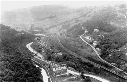
Photo lent by Don and Leah Coneron.
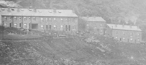
This photo was taken from the South hillside with Woodland view in the foreground. Beyond the railway line Knott Hall is on the left, Old Charlestown and Stoney Lane are in the centre with Turret Royd just above. Turret Hall (Wood farm) can be seen on the top right hand side).
The information below on Underbank House and Knott Hall has been kindly provided by Rick Horsfall from South Carolina in the USA who has been researching this area for many years. Rick's family, the Underbank Horsfalls have been connected to the Underbank area and Underbank House from at least the 1550's until 1966.They were originally yeoman farmers who later became involved in wool goods and cotton manufacturing in Charlestown.
UNDERBANK HOUSE
Sixteenth Century
The Great House built in the Tudor period was in the shape of a T.The top part of the "T" faced north/south and the stem of the "T" ran east/west. The present house appears to be as wide (east/west) as the Great house and almost as deep as the North/South portion of the Great House.
This Great House predates the dwelling at Upper (Higher) Underbank and it is thought to have been built in 1525. William Horsfall wrote a letter to Joseph Horsfall Turner dated August 8th, 1889. In the letter he states that "I have always understood there was a figure of the Virgin Mary in the plaster work in the old parlour in the ancient house at Underbank that stood upon the site of this house".
Joseph Horsfall Turner who was a local historian wrote an interesting response. Mr. Turner's reply supposed two possibilities. One could be the Underbank's connection to the Bishop John Horsfall of Kilkenny, Ireland (1586 to 1609). The other and more probable explanation he thought was relationship to Robert Fferrar who was martyred in 1555 during the reign of Queen Mary. The founder of the Underbank Horsfalls was also a Richard that died in 1557. Richard's daughter in law was as well as the husband of his aunt was a Fferrar.
East from the Tudor House was a stone barn with the entrance facing East. The old barn was built in 1585. Here is an excerpt of a letter written by a Richard Hamilton Horsfall (the son of John Lister Horsfall) addressed to William:
"The old barn ran lengthwise from the present carriage drive to opposite the yard well. It was only 4 yards from the present house. (This why there was not window on the east wall of the dining room in the new Underbank house). The old barn had a water wheel, it being used for grinding corn."
Eighteenth Century
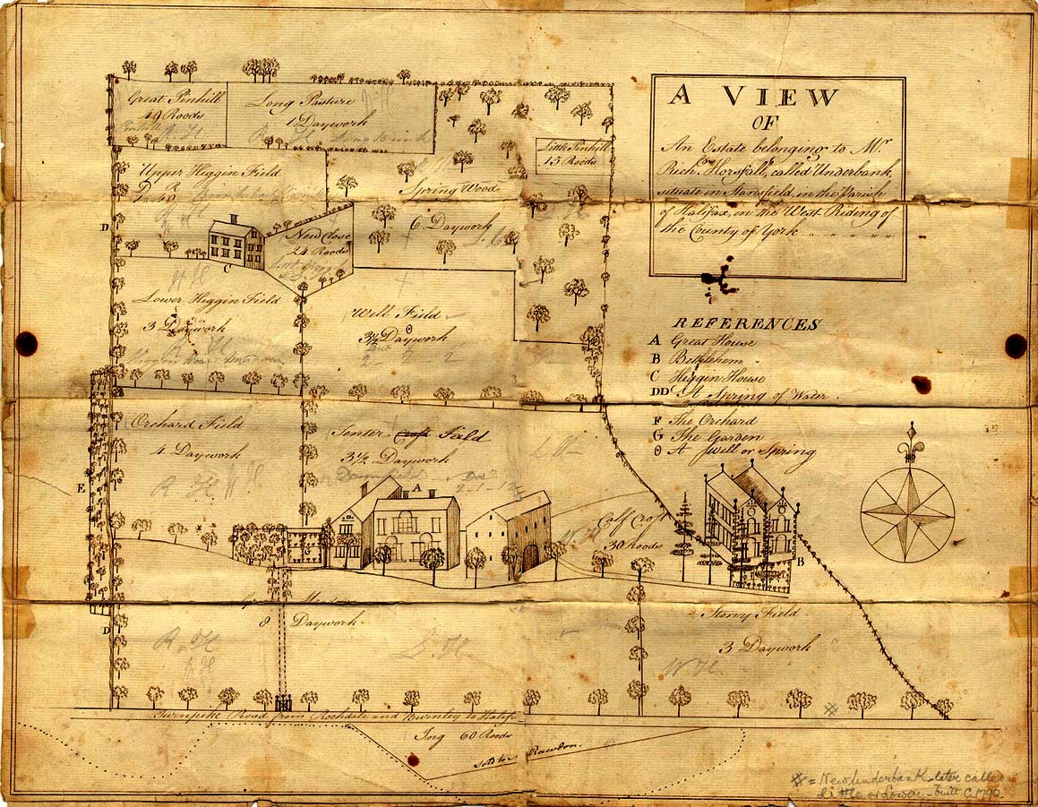
Rick has sent us the wonderful map below which is dated around 1774. In 1774 Richard Horsfall sold Underbank, but kept Bethlehem, so perhaps the map was drawn for this purpose. The map shows the houses and gardens in the area and includes the turnpike and field systems.
Most of the fields on the map are measured in daywork which is fairly self explanatory. Two of the smaller fields are measured in roodes. A roode is an old English term meaning " a square pole or perch (5 yards square) but with local variations ..... a rood of ground was considered enough to maintain a man".
Nineteenth Century
The present Underbank House was built and completed in the summer of 1835. John Lister Horsfall, the son of William Horsfall, oversaw the construction (there is some discrepancy here, the accounts of Richard Horsfall show that it was built in 1820).

William Horsfall was the owner of Winters Mill (a spinning and weaving mill for cotton higher up the hillside).
William was the third oldest son of Richard and Mary (Eastwood) Horsfall. Upon Richard's death in 1827 (87 years old), the Underbank property passed to his youngest son, Luke. Luke sold Underbank to his brother William and Luke moved to Halifax.
Soon after William purchased Underbank and its estate, William decided to pull down the old Tudor House and build a new house. Further details about the rebuilding are on the archive page.
In the 1851 census it was occupied by John Lister Horsfall (a local farmer and cotton manufacturer) his wife, Sarah and three children.
The water system
The fast flowing stream that comes down from Winters comes down to the West of Underbank House.
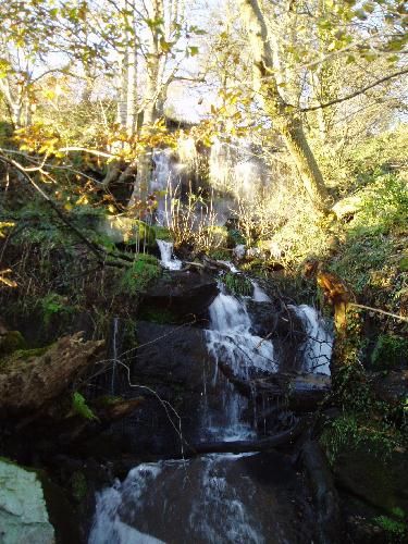
At some point, the owners of Underbank house decided that the stream was unsightly and had to be tidied away. This was done by sinking an underground goit that takes the stream under the railway and into the River.

The goit follows by the side of the stone steps leading down to Underbank Hoe.
After the present Underbank house was completed, the old barn which was used to grind corn remained there until about 1852/55 when it was torn down and relocated to it present site. John Lister Horsfall, who oversaw the demolition and construction of Underbank House, had the barn rebuilt and made into a Coach House.
Someone called Alf lived in the coach house in the 1950s. It was later converted into a house. The sunken path behind underbank House was referred to locally as Duckfly (as was the house). The reason was that there was a large flock of ducks which used to fly up when people came a long the path.
KNOTT HALL and KNOTT WOOD
The present house and two cottages date from about 1831 when they owned and occupied by a Sarah Pilling. A house called Bethlehem stood where Knott Hall presently stands (also shown on the map described above). Bethlehem was twin gabled house and has features on the south and west exposures for the first and second floors.It appears to have no chimneys.
Why the house was called Bethlehem is unknown. The Horsfalls have been associated with Heptonstall and St. James churches for centuries. It may be that the Richard Horsfall who sold Underbank to his nephew was a non-conformist. Perhaps persons reading this who are familiar with the non-conformist activities of the 18th and 19th centuries can find references to this structure called Bethlehem.
Here is what Sydney Horsfall has to say about Bethlehem and Knott Hall. "Richard (born 1725 and died 1785/8) sells Underbank and retains Bethlehem himself and his wife also a Mary. Mary lives in the house until her death in 1803/5. Sydney said that there is a head stone on the retaining wall for the "old cottages" marked R.M.H. 1770. This head stone was in the Bethlehem house. This head stone has never been found, but Sydney refers to "old cottages" as the Knott Hall cottages. The stone was bought by a postman in the 1960s, but all trace of it has gone,
Sydney's notes also state that Bethlehem was torn down about 1830/1. From these stones Knott Hall cottage(s) were built. Knott Hall cottage(s) were built of the site of lower Knott Hall gardens. There are no records that any Horsfalls lived in Knott Hall. At some point Knott Hall passed from the Underbank Horsfalls.The house was occupied by the foreman of Callis Mill.
In the 1851 census, it was occupied by Andrew Aspden (a retired worsted spinner) and his family. The two cottages were occupied by George Clegg (a carder) and Jas. Hartley (a cotton spinner).
In 1870 John (a carder) and Elizabeth Midgely lived at Knott hall and had a son William. Knott Hall was occupied in the 1950s by Police Inspector Whittingham of Todmorden
The field in front of Knott Hall provided water for Callis Mill, Woodland View and the Woodman. The water was probably supplied by a small beck which still runs past Knott Hall Cottages. We are not quite sure whether this means there was a dam on this site. It is said that when water was short, the mill frequently shut off the water to domestic dwellings.
Knott Wood was part of the Savile estate. It was sold to the water Board before the second world war who later sold it to the owners of the Turret Hall estate. The wood has recently been managed by Knott Wood Coppicers, a local group who set up a charcoal making business.

This photo provided by Rick Horsfall dates from 1900. It shows the site of the old Woodman and the layout of old Charlestown.
OLD CHARLESTOWN
The present site of the Air Training Corps is the original site of Charlestown. On this incredibly small site there were 14 back to back dwellings. Two pieces from the Todmorden Almanac report that in July 1830 a child was born with four legs! and in 1880, "scarlatina of a malignant type broke out causing two fatal cases, the origin was undiscovered".
We don't know the date the terraces were built were built at present.
- In the 1851 census 68 people living there with 7 vacant houses
- In the 1920s several houses were empty
- In the 1920s one of the dwellings was a cobblers shop run by Teddy Speak who was also known as peg leg
- A Mrs Johnston ran a bakers from her house making onion and potato cakes and who used to supply dinners for Callis Mill.
- There was a sweet shop that was run from someone's front room.
Old Charlestown was demolished in the mid 1950s and became lock-up garages.
STONEY LANE (also known as South View)
Just up from Old Charlestown, these dwellings were also in existence before 1850, but we don't know the date they were built at present. Stoney Lane was the site of Holts Botanical Brewery run by Billy Holt's father (for more details about the Billy Holt erstwhile communist, traveller and broadcaster and all round eccentric see people. In his auto biography he describes the brewery: "The old brewery was in the cellars of a ramshackle building, underneath some cottages. There were four stone flagged cellars with uneven floors about the size of a cottage room. In the first one were broad wooden shelves filled with stone bottles and bins of dried herbs, ginger, hops, burdock, sassafras bark, saccharine, and soft block licorice. The tiny office, with its high desk in one corner of the cellar, was an indescribable confusion of billheads and coloured bottle labels.

The second cellar contained an enormous set-pan and three large barrels which stood on end and reached up to the whitewashed ceiling. In the third cellar there was a bottle washing machine. It was merely a zinc lined wooden tank on legs with a central water-pipe carrying a dozen brass nipples. When the tap was turned on twelve fountains of water spread fan-wise, upward and outward. The fourth cellar was a chaotic litter of broken bottles, wicker crates and straw. My father brewed his beverages in the set-pan on brewing days and filled his barrels; my Grandfather Holt did the bottling. During the school holidays I helped to screw in the stoppers.
...My Grandfather seated himself on a stool in front of a galvanized tin bath which caught the frothing liquid as it came from a wooden tap in one of the wooden barrels. He used a quart tin measure and a funnel, which he shifted from bottle to bottle as he filled them. and we screwed in the stoppers. Sometimes he recited long passages from Shakespeare, his favourites being the speeches of Hamlet's ghost, which he recited in a deep, blood curdling voice which echoed through the cellars.....Then came the fascinating task of labelling with a paste brush and the carrying the bottles to the shelves in the first cellar....
Very hard times had come to my parents at Stoney lane. The brewery was not profitable. Customers were keeping the empty bottles to use as hot water bottles in the winter and refusing to buy my father's brews if he charged a deposit on the bottle"
At present we do not know the exact location of the Brewery,
TURRET ROYD
The original terrace of four houses were probably built in the 1880s. The other houses were built by Tommy Stansfield in the 1920s.Tommy built many houses in the district and because there were so many Stansfields in the locality, he was known by the by-name of Nudger. By-names were a common way of identifying individuals in large local families (others include Plush Greenwood and Dick Straight Up Greenwood in Heptonstall).
TURRET HALL
Turret Hall (now called Wood Farm) was originally part of the Savile estate (the biggest landowner in the district). In the 1851 census, the occupiers were listed as John Southwell (a farmer's man) and Robert Sutcliffe (a retired corn miller) In 1897 the Turret Hall Estate was sold by Baron John Savile to a Richard Greenwood. Richard Greenwood built several dwelling on the Turret Hall Estate (Undercragg, Fernley cottages, Throstle Bower and Beechwood View). These were sold off by this heir Charles Greenwood mainly around 1924, but the new owners had to pay the estate for water until town water came in the 1970s.. The Turret Hall Estate has since been through several ownerships.
The present owners believe that Turret Hall was in a slightly different position to the present site of Wood Farm. Further research will be needed to discover the history of Turret Hall.
FERNLEY COTTAGES
This row of four houses is situated above Knott Wood. Richard Greenwood, who owned Turret Hall Estate built Fernley Cottages around 1900. In the 1930s, just behind Fernley Cottages, there were pitch and toss gambling sessions on Sundays in a delph (quarry).
OAKVILLE ROAD
Stoney Lane and Oakville Road formed the main route from Todmorden to Hebden Bridge before the present road in the Valley bottom was created.

There was reputed to be a toll bar somewhere along this road. We think that it was situated just below the junction of Stoney Lane, Turret Royd and Oakville road. The field at this point used to be known as Bar Field and on the 1882 survey a small roadside building is shown.
Photo from Alice Longstaff collection.
Most of the present terraces were built before 1880 with Beechwood View being a later addition, built by The turret Hall Estate around 1900. In the middle of Beechwood View is an archway with a dwelling above. This was used as a maternity hospital in the Second World War, run by Kasia and Mabel Sutcliffe.
We think this photo was taken between 1910 and 1920.
Oak Villas was built by Charles Greenwood in 1881 (there is a date on the end of the terrace). At the top of Oak Villas there is a gap in the terrace. In this space there was a smithy run by Isaac Eastwood with a dwelling above. Later on he and his two sisters Eva and Anna made potted meat by boiling bones which gave off an awful smell. The house at the bottom of the terrace was reputed to have been a soap works at some time.
The land between Oakville Road and the railway was call the Pen Trough (now called the Pen), probably after all the smallholdings that were on it. One set of huts had big white signs saying "Rat Catcher" and "Woodshed Tripe Works opposite".
An underground tunnel runs under the Pen but we are not sure what it it. Two theories are that it was to do with an attempted railway tunnel or that it was a goit that rain from Callis Mill. A team of cavers descended into the tunnel and their survey seems to reject both theories.
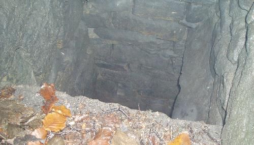
Pen shaft
You can see from the photo that the shaft is beutifully constructed out of dry stone. At the bottom there are tunnels going off, but unfortunately at the time of the survey they were full of water.
The view of the surveyors was "The tunnel at the bottom looks rather unstable ................ It looks like the tunnel runs in both directions from the bottom, however you can only see up it to the right. It is probably an unfinished tunnel in the digging stage. It shows no sign of block-work as might be expected. It looks more like a mine than a tunnel and it looks like the tunnel has been dug then the shaft, and the two connected at the bottom".

Photo from Alice Longstaff collection.
Above Oakville Road is Rawtonstall Wood which originally was part of the Savile Estate. The wood has three cleared areas.
First there was a stone quarry above Calderside. The quarry was owned by Tommy Stansfield who employed 7 or 8 men. Tommy was a well known local builder ( for more details on Tommy Stansfield). The quarry later became Calderside (plant) Nursery and now a private dwelling.

The second clearing in Rawtonstall wood is behind the quarry and is a small flat piece of land known locally as the Batting Spot (presumably because it was used as an unofficial games area, being one of the few flat areas of land in the area). The Batting spot is now fenced off and used to store stone.

The third area was cleared to make a bowling green. Click here for the Mytholm page where there is more information on the bowling club.
CALDERSIDE
At the bottom of Oakville Road the roadway ran through the middle of Calderside Mill.

Photograph from Jack Uttley collection.
The photo shows the two terraces of King Street with Calderside to their left. Calderside Mill is next to Whitely Arches.
The seven dwellings presently called Calderside predate 1880.
Calderside Mill
Calderside Mill was built by John Whitely as a five storey cotton mill in 1824 (presumably Whiteley Arches was named after the Whitely family).
In 1875 the mill was converted into a dye works by the Calderside Company.
In 1899 the Mill was being run by William Williamson under the name of The Calderside Dyeing Company.

Calderside Mill had a 300 foot chimney which in 1842 was said to be the tallest in the district (the stump of the dye works chimney can be seen next to Whitely Arches).

In the 1960s the mill was demolished and 2 houses built on part of the site.
Nothing remains of this mill except a few large blocks of stone. At present (2009) the site has been cleared for 8 new houses to be built.
Go to the Mills page for more detailed information on Calderside Mill.
This page was last updated April 2009